![](/images/other/stat-length.png)
![Excursión A pie Wald (BE) - Englisberg - Hofmatt - Photo](https://media.geolcdn.com/t/1900/400/fbb302ea-01ec-449e-b072-cce95446376d.jpeg&format=pjpeg&maxdim=2)
Englisberg - Hofmatt
SityTrail - itinéraires balisés pédestres
Tous les sentiers balisés d’Europe GUIDE+
![Longitud](/images/other/stat-length.png)
Longitud
3,1 km
![Altitud máxima](https://static1.geolcdn.com/siteimages/upload/files/1508320355ic_sort_altitude_max_24dp.png)
Altitud máxima
832 m
![Desnivel positivo](https://static1.geolcdn.com/siteimages/upload/files/1508320355ic_sort_den_pos_24dp.png)
Desnivel positivo
45 m
![Km-Effort](/images/other/stat-length.png)
Km-Effort
4 km
![Altitud mínima](https://static1.geolcdn.com/siteimages/upload/files/1508320355ic_sort_altitude_min_24dp.png)
Altitud mínima
725 m
![Desnivel negativo](https://static1.geolcdn.com/siteimages/upload/files/1508320355ic_sort_den_neg_24dp.png)
Desnivel negativo
132 m
![Boucle](https://static1.geolcdn.com/siteimages/upload/files/16400158638029165_repeat_loop_refresh_sync_direction_icon.png)
Boucle
No
Baliza
Fecha de creación :
2022-02-14 08:52:19.867
Última modificación :
2022-02-14 08:52:19.867
![A pie](https://static1.geolcdn.com/sitytour/trail-icons/100.png)
53m
Dificultad : Fácil
![Escanee este código QR para abrir la excursión en la aplicación SityTrail](https://capi.geolives.com/qq0zvz2zws4bq2lad0pu/sitytour/trails/3106511/qr.png?size=200)
Aplicación GPS de excursión GRATIS
A propósito
Ruta A pie de 3,1 km a descubrir en Berna, Verwaltungskreis Bern-Mittelland, Wald (BE). Esta ruta ha sido propuesta por SityTrail - itinéraires balisés pédestres.
Descripción
Trail created by Berner Wanderwege.
Symbol: gelber Diamant
Localización
País:
Switzerland
Región :
Berna
Departamento/provincia :
Verwaltungskreis Bern-Mittelland
Municipio :
Wald (BE)
Localidad:
Unknown
Salida:(Dec)
Salida:(UTM)
383401 ; 5194823 (32T) N.
Comentarios
Excursiones cerca
![Excursión A pie Toffen - Toffen - Belp - Photo](https://media.geolcdn.com/t/375/260/15b55688-b3f9-47dd-a7d6-3a44c58cd1dc.jpeg&format=jpg&maxdim=2)
![A pie A pie](https://static1.geolcdn.com/sitytour/trail-icons/100.png)
Toffen - Belp
A pie
Fácil
Toffen,
Berna,
Verwaltungskreis Bern-Mittelland,
Switzerland
![](/images/other/stat-length.png)
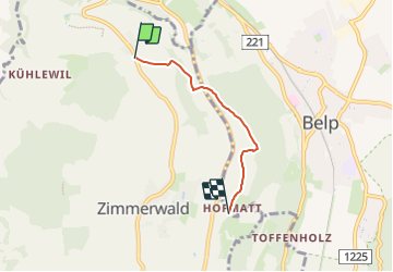
3,4 km | 3,5 km-effort
48min
![](https://static1.geolcdn.com/siteimages/upload/files/16400158638029165_repeat_loop_refresh_sync_direction_icon.png)
No
![Excursión A pie Köniz - Leimen - Lisiberg - Photo](https://media.geolcdn.com/t/375/260/ext.jpg?maxdim=2&url=https%3A%2F%2Fstatic1.geolcdn.com%2Fsiteimages%2Fupload%2Ffiles%2F1545311037marcheuse_200dpi.jpg)
![A pie A pie](https://static1.geolcdn.com/sitytour/trail-icons/100.png)
Leimen - Lisiberg
A pie
Fácil
Köniz,
Berna,
Verwaltungskreis Bern-Mittelland,
Switzerland
![](/images/other/stat-length.png)
3,3 km | 6,6 km-effort
1h 30min
![](https://static1.geolcdn.com/siteimages/upload/files/16400158638029165_repeat_loop_refresh_sync_direction_icon.png)
No
![Excursión Senderismo Köniz - Berne - Photo](https://media.geolcdn.com/t/375/260/376682f7-04b0-44c2-aae8-bd130947a51d.jpg&format=jpg&maxdim=2)
![Senderismo Senderismo](https://static1.geolcdn.com/sitytour/trail-icons/101.png)
Berne
Senderismo
Medio
Köniz,
Berna,
Verwaltungskreis Bern-Mittelland,
Switzerland
![](/images/other/stat-length.png)
6,4 km | 8,3 km-effort
2h 11min
![](https://static1.geolcdn.com/siteimages/upload/files/16400158638029165_repeat_loop_refresh_sync_direction_icon.png)
No
![Excursión Senderismo Belp - st_GL_gantrisch - Photo](https://media.geolcdn.com/t/375/260/ext.jpg?maxdim=2&url=https%3A%2F%2Fstatic1.geolcdn.com%2Fsiteimages%2Fupload%2Ffiles%2F1553511878bg_sport_marche.png)
![Senderismo Senderismo](https://static1.geolcdn.com/sitytour/trail-icons/101.png)
st_GL_gantrisch
Senderismo
Muy fácil
Belp,
Berna,
Verwaltungskreis Bern-Mittelland,
Switzerland
![](/images/other/stat-length.png)
54 km | 81 km-effort
13h 49min
![](https://static1.geolcdn.com/siteimages/upload/files/16400158638029165_repeat_loop_refresh_sync_direction_icon.png)
No
![Excursión Senderismo Köniz - hike07_24 - Photo](https://media.geolcdn.com/t/375/260/ext.jpg?maxdim=2&url=https%3A%2F%2Fstatic1.geolcdn.com%2Fsiteimages%2Fupload%2Ffiles%2F1553511878bg_sport_marche.png)
![Senderismo Senderismo](https://static1.geolcdn.com/sitytour/trail-icons/101.png)
hike07_24
Senderismo
Muy fácil
Köniz,
Berna,
Verwaltungskreis Bern-Mittelland,
Switzerland
![](/images/other/stat-length.png)
7,5 km | 11,9 km-effort
2h 13min
![](https://static1.geolcdn.com/siteimages/upload/files/16400158638029165_repeat_loop_refresh_sync_direction_icon.png)
Sí
![Excursión Senderismo Toffen - Toffen-Bütschelegg-Thurnen - Photo](https://media.geolcdn.com/t/375/260/ext.jpg?maxdim=2&url=https%3A%2F%2Fstatic1.geolcdn.com%2Fsiteimages%2Fupload%2Ffiles%2F1553511878bg_sport_marche.png)
![Senderismo Senderismo](https://static1.geolcdn.com/sitytour/trail-icons/101.png)
Toffen-Bütschelegg-Thurnen
Senderismo
Muy fácil
Toffen,
Berna,
Verwaltungskreis Bern-Mittelland,
Switzerland
![](/images/other/stat-length.png)
14,7 km | 23 km-effort
3h 30min
![](https://static1.geolcdn.com/siteimages/upload/files/16400158638029165_repeat_loop_refresh_sync_direction_icon.png)
No
![Excursión Senderismo Belp - Vorfrühling an Aare und Belpberg - Photo](https://media.geolcdn.com/t/375/260/ext.jpg?maxdim=2&url=https%3A%2F%2Fstatic1.geolcdn.com%2Fsiteimages%2Fupload%2Ffiles%2F1553511878bg_sport_marche.png)
![Senderismo Senderismo](https://static1.geolcdn.com/sitytour/trail-icons/101.png)
Vorfrühling an Aare und Belpberg
Senderismo
Muy fácil
Belp,
Berna,
Verwaltungskreis Bern-Mittelland,
Switzerland
![](/images/other/stat-length.png)
15,1 km | 21 km-effort
4h 30min
![](https://static1.geolcdn.com/siteimages/upload/files/16400158638029165_repeat_loop_refresh_sync_direction_icon.png)
Sí
![Excursión Otra actividad Belp - Belp - Wimmis - Photo](https://media.geolcdn.com/t/375/260/ext.jpg?maxdim=2&url=https%3A%2F%2Fstatic1.geolcdn.com%2Fsiteimages%2Fupload%2Ffiles%2F1545311037marcheuse_200dpi.jpg)
![Otra actividad Otra actividad](https://static1.geolcdn.com/sitytour/trail-icons/900.png)
Belp - Wimmis
Otra actividad
Muy fácil
Belp,
Berna,
Verwaltungskreis Bern-Mittelland,
Switzerland
![](/images/other/stat-length.png)
32 km | 37 km-effort
5h 21min
![](https://static1.geolcdn.com/siteimages/upload/files/16400158638029165_repeat_loop_refresh_sync_direction_icon.png)
No
![Excursión Otra actividad Belp - Belpberg - Photo](https://media.geolcdn.com/t/375/260/ext.jpg?maxdim=2&url=https%3A%2F%2Fstatic1.geolcdn.com%2Fsiteimages%2Fupload%2Ffiles%2F1545311037marcheuse_200dpi.jpg)
![Otra actividad Otra actividad](https://static1.geolcdn.com/sitytour/trail-icons/900.png)
Belpberg
Otra actividad
Muy fácil
Belp,
Berna,
Verwaltungskreis Bern-Mittelland,
Switzerland
![](/images/other/stat-length.png)
11,1 km | 16,4 km-effort
Desconocido
![](https://static1.geolcdn.com/siteimages/upload/files/16400158638029165_repeat_loop_refresh_sync_direction_icon.png)
No